Grow Terrain from Local Height Rules
Cellular Automata From First Principles 15: Grow Terrain from Local Height Rules
Binary caves ask:
wall or floor?
Terrain needs richer state.
Let each cell store a height:
0.0 = low
1.0 = high
Now local rules can smooth, raise, erode and classify terrain.
The challenge is not creating a pretty array.
It is creating a process whose output we can explain and control.
Start with a height field
import numpy as np


def random_heightmap(
    rows=120,
    cols=160,
    seed=42,
):
    rng = np.random.default_rng(seed)

    return rng.random(
        (rows, cols)
    )
Raw independent noise contains variation but little large-scale geography.
Add a local mean
def local_mean(grid):
    total = np.zeros_like(grid)

    for dy in (-1, 0, 1):
        for dx in (-1, 0, 1):
            total += np.roll(
                np.roll(
                    grid,
                    dy,
                    axis=0,
                ),
                dx,
                axis=1,
            )

    return total / 9.0
Blend toward the neighborhood:
def smooth_step(
    height,
    strength=0.35,
):
    mean = local_mean(height)

    return (
        (1 - strength) * height
        + strength * mean
    )
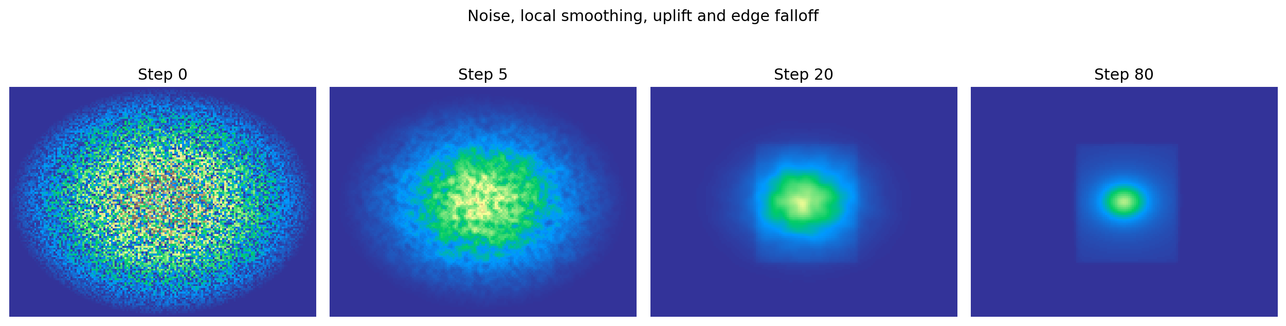
Repeated smoothing creates broad spatial regions.
But smoothing alone is not a terrain generator.
If we continue forever, it removes differences.
Add a competing process
Introduce persistent uplift:
uplift = np.zeros_like(height)

uplift[
    30:92,
    55:108,
] = 0.003
Then:
def terrain_step(
    height,
    uplift,
):
    height = smooth_step(
        height,
        strength=0.35,
    )

    height = height + uplift

    return np.clip(
        height,
        0.0,
        1.0,
    )
Now two local/global influences compete:
smoothing
    -> reduces sharp local differences

uplift
    -> continually creates elevation
The renderer also applies a gentle radial edge falloff so the demonstration develops an island-like boundary.
Inspect the final height field directly

This is important: the primary generated object is the height field.
Water, plains, hills and mountains are interpretations derived from it.
Derive semantic terrain classes
WATER = 0
PLAINS = 1
HILLS = 2
MOUNTAINS = 3


def classify_height(height):
    terrain = np.zeros_like(
        height,
        dtype=np.uint8,
    )

    terrain[
        (height >= 0.35)
        & (height < 0.55)
    ] = PLAINS

    terrain[
        (height >= 0.55)
        & (height < 0.75)
    ] = HILLS

    terrain[
        height >= 0.75
    ] = MOUNTAINS

    return terrain
This separates:
simulation / generation state:
continuous height

game-facing interpretation:
terrain class
That separation keeps the underlying process reusable.
Add a second continuous field
Height alone does not determine every world property.
Add moisture:
moisture = np.zeros_like(height)

moisture[:, :20] = 1.0
Diffuse it inland:
for _ in range(100):
    moisture = (
        moisture
        + 0.1 * laplacian(moisture)
    )

    moisture[:, :20] = 1.0
Now each cell can be thought of as:
[height, moisture]
and biome classification can depend on both.
The grid is becoming a layered local state machine.
Global design goals should remain explicit
A game may require:
30-45% water
one large connected continent
flat spawn region
mountains away from spawn
river reaches ocean
Do not force a cellular smoothing rule to guarantee all of those.
Use:
local rules
    -> organic structure

measurement
    -> evaluate candidate

graph/search constraints
    -> guarantee global requirements
This is the same lesson we learned from cave generation.
Measure the world
def terrain_stats(
    height,
    water_level=0.35,
):
    return {
        "mean_height": float(
            height.mean()
        ),
        "height_std": float(
            height.std()
        ),
        "water_fraction": float(
            np.mean(
                height < water_level
            )
        ),
        "mountain_fraction": float(
            np.mean(
                height > 0.75
            )
        ),
    }
Now seeds and parameter sets can be searched instead of judged only by screenshots.
One idea to keep
Terrain generation becomes easier to reason about when we separate three layers:
continuous generated fields
       ↓
derived semantic classes
       ↓
global design constraints
Local CA-style rules are excellent at producing spatial texture.
They do not need to carry every high-level requirement themselves.
In the next chapter we will use the same local machinery without pretending to simulate a world at all: we will deliberately treat cellular rules as visual texture generators.
